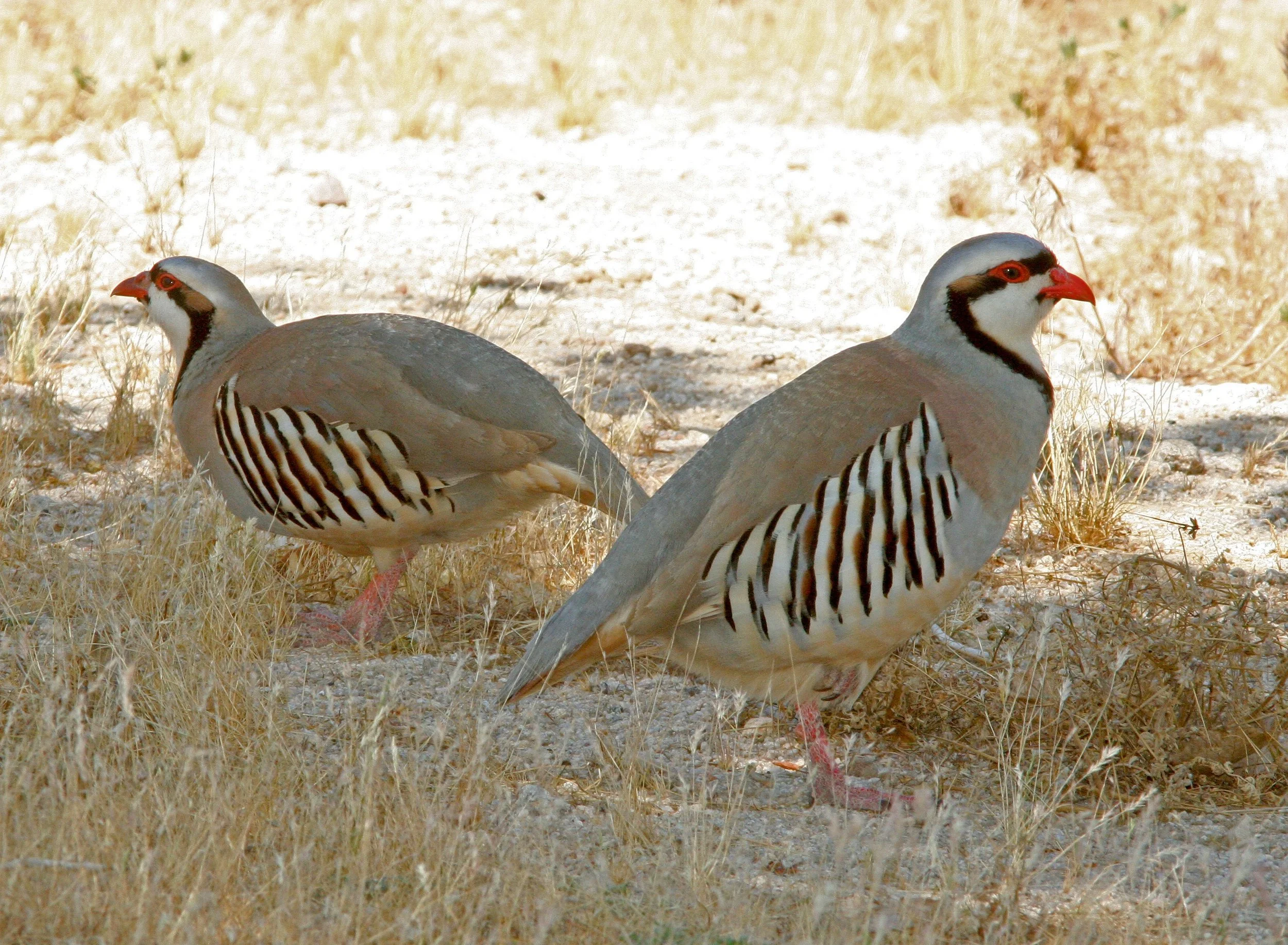
Chukar on dry ground in the Kern County desert, east of the Tehachapis, May 2009. Photo: Alan Schmierer / CC0 — source
I have not hunted the Tehachapi Mountains. I have driven Highway 58 through the pass more times than I can count, and every single time — Bakersfield behind me, the windmill ridges above, sage running up to broken rim rock — I have thought that is chukar country, and then kept driving.
The why is geological, and it is the reason this range deserves a piece of its own rather than a paragraph in somebody's eastern Sierra guide. The Tehachapis are a seam. The southern tip of the Sierra Nevada physically bends into the Transverse Ranges here, the Mojave Desert pushes against the range from the east, and the southern San Joaquin Valley presses in from the west. Three geological provinces meeting in one low range produces something California has almost nowhere else: three distinct upland bird communities inside a day's walk of each other. Chukar (Alectoris chukar) coming in from the Great Basin, California quail (Callipepla californica) from the coastal chaparral, and Gambel's quail (Callipepla gambelii) at the northwestern edge of their Sonoran range.
Alan complicates that in a way worth saying out loud. He is a three-year-old English cocker — a flushing dog built for chamise and ditch banks, not for grinding basalt rim at 6,000 feet all day. So the traverse below is not a route I would walk end to end with him. It is a menu, and the version of this trip Alan and I do together starts low in the quail belts and only touches the chukar country in the mornings, with his water on my back and a hard turnaround time. A range that offers three birds does not oblige you to chase all three in one day, and pretending otherwise is how dogs get hurt.
So this piece runs west to east, the way the country actually changes.
West End of the Tehachapis: Tejon and the Access Problem
The I-5 corridor and the Tejon Pass country is the most productive low ground in the range and almost none of it is yours. Tejon Ranch — the largest contiguous private holding in California — occupies the southwestern half, and public access is limited to specific easements and scattered small BLM parcels in the surrounding foothills. The Tejon Ranch Conservancy's habitat work on that ground is real and it matters ecologically, but it does not convert into walk-in opportunity for a hunter with a public-land map.
Which is the first thing to understand about this range: the west end looks like the best of it from the freeway, and the freeway is as close as most hunters will get.
The Piute Bridge Off the Southern Sierra
North and west of the main range, the Piute Mountains carry Sequoia National Forest ground and form the physical bridge down from the southern Sierra Nevada. Mixed conifer up high, pinyon-juniper and sage at mid-elevations, chamise below the conifer line. Chukar hold on the south-facing bunchgrass benches; California quail work the chamise edges under them, with access off the Caliente-Bodfish Road network. This is the piece of the range that most resembles country I already know from the Nevada side of the Sierra, which is either an advantage or a bias, and I am not yet sure which.
The Main Ridge, and the Case for Chukar
Tehachapi Mountain proper is the high ground of the range, and which of its slopes are open to a shotgun has to come off a current land-status map, not the view from Highway 58 — much of this range is private, and I have not yet pinned down which upper slopes are public. Sagebrush and chamise below, conifer on the north slopes, basalt rim with escape cover beneath it and seeps at mid-elevation. Structurally, it is a chukar mountain.
The accounts I have gathered say the birds are real. Chukar were stocked across the West from the 1930s on, the reports put a population on this range for decades, and CDFW's statewide chukar range layer (CWHR B132) is where I am checking that against any unit before the drive. The Tehachapis sit at the southwestern range edge for chukar in California, with the Owens Valley and the Modoc Plateau as the strongholds.
By those same accounts, three things make them different from Owens or Modoc birds, and all three come out of the seam. The productive belt sits between roughly 3,500 and 6,500 feet — a thousand feet lower than the comparable Owens country, which is easier on a hunter and considerably easier on a dog. There are more reliable springs per square mile than Modoc offers, though still scarce by any coastal standard. And the quail belts sit directly underneath, so this is one of very few chukar destinations where the lower-elevation consolation prize is a good second bird in its own right.
East End: Where the Desert Takes Over
Drop off the eastern side toward the Antelope Valley and the transition happens fast — sagebrush gives way to creosote scrub inside a few miles of elevation loss. California quail and Gambel's quail mix through that band, on BLM ground. This is the end of the range where the premise becomes visible in the cover itself: Great Basin sage behind you, Mojave creosote in front, and the birds sorting themselves along that line without any regard for how a hunter planned his morning.
What the Traverse Means for a Two-Day Plan
Two days does not cover this range; it covers a slice of it. The two Bakersfield hunters I talked to both work the central USFS and BLM parcels first and the Piute section second, and neither tries to combine the chukar rim and the eastern desert edge in the same trip. I intend to follow that.
The practical shape, as I have it drawn: chukar rim in the first two hours of light while it is cold, drop into the quail belts mid-morning when the rim heats up and Alan's usefulness peaks, off the mountain by early afternoon. A fall day here can swing from around 40°F at first light to 75°F by eleven — layers coming off in stages, and a dog whose water need triples across the same window.
The gear follows from that. The 20-gauge comes, and the shells are a pattern-board decision I have not made yet: bismuth for the quail belts, something heavier for the rim, both settled on paper before the first trip rather than off the box, the way our nonlead patterning piece lays it out. Six liters of water for me plus a full budget for Alan, because the Mojave-adjacent springs are less dependable than the map implies, and snake gaiters until a hard cold snap, since rattlesnake activity here can run into November in mild years.
Reading the Seam Before You Drive
The pre-trip work is water, burns, and roads, in that order.
Water first, as on every chukar mountain: I am marking every spring, stock tank, guzzler, and seep within half a mile of basalt rim, using the BLM resource management plan documents for the developed water and USGS topo overlays for the rest. Burn history second — CAL FIRE's fire perimeter data shows which slopes have burned and when, our fire layer on the upland map puts the recent ones in one place, and regrowth in the four-to-eight-year window is good cover for chukar and quail alike. Roads last and most urgently, because the Tehachapi network carries seasonal closures for fire and erosion; the Sequoia NF maps and MVUM and the BLM Bakersfield office are where I am checking, and a scouting day that skips that step turns into a tailgate-and-look day.
Camping is sparse and simple: developed Forest Service campgrounds in the Piute section, dispersed camping on BLM and USFS ground under standard rules, or a motel in Tehachapi off Highway 58 if the weather turns. Cell service is decent at the pass and absent in the back drainages.
On the regulations: the Tehachapis sit in quail Zone Q3, and for 2026-27 both seasons run from Saturday, Oct. 17, through Jan. 31 — chukar at 6 a day and 18 in possession, quail at 10 and 30, per CDFW's upland game bird page. Nonlead shot has been required for any take with a firearm anywhere in California since July 1, 2019.
The Honest Ceiling
Here is the thing I would want told to me, and it is not flattering to the trip: bird density here is lower than Owens and lower than Modoc. Nobody in the accounts I have read describes filling a six-chukar limit. What they describe is a productive two-to-four-bird day, earned over a lot of ground — a different kind of good, and not a substitute for the first kind. A hunter who drives down expecting the Owens Valley will leave disappointed, and will be right to.
But a range that puts three bird communities on one mountain because three geological provinces collide underneath it is worth walking for reasons that do not fit in a game bag. The Tehachapis are the hinge California's upland country turns on — Great Basin above, chaparral west, desert east — and standing where those three arguments meet seems like a thing a person who writes about California birds ought to have done.
If you hunt this range and want to tell me where the above is wrong, particularly on which BLM units are worth a first day, hello@californiaupland.com.
Related reading:
External: USFS Sequoia National Forest · BLM Bakersfield Field Office · CDFW Upland Game Bird Hunting
Get the weekly digest. One email each Sunday with the week's pieces, plus the California Upland Season Dates & Limits Cheatsheet PDF as a free download for new subscribers. Subscribe →
Peter Burnham grew up in Nevada hunting chukar in the Sierras and dove in the valleys and hunts behind Alan (a three-year-old English cocker). Read more → · Subscribe to the weekly digest →

