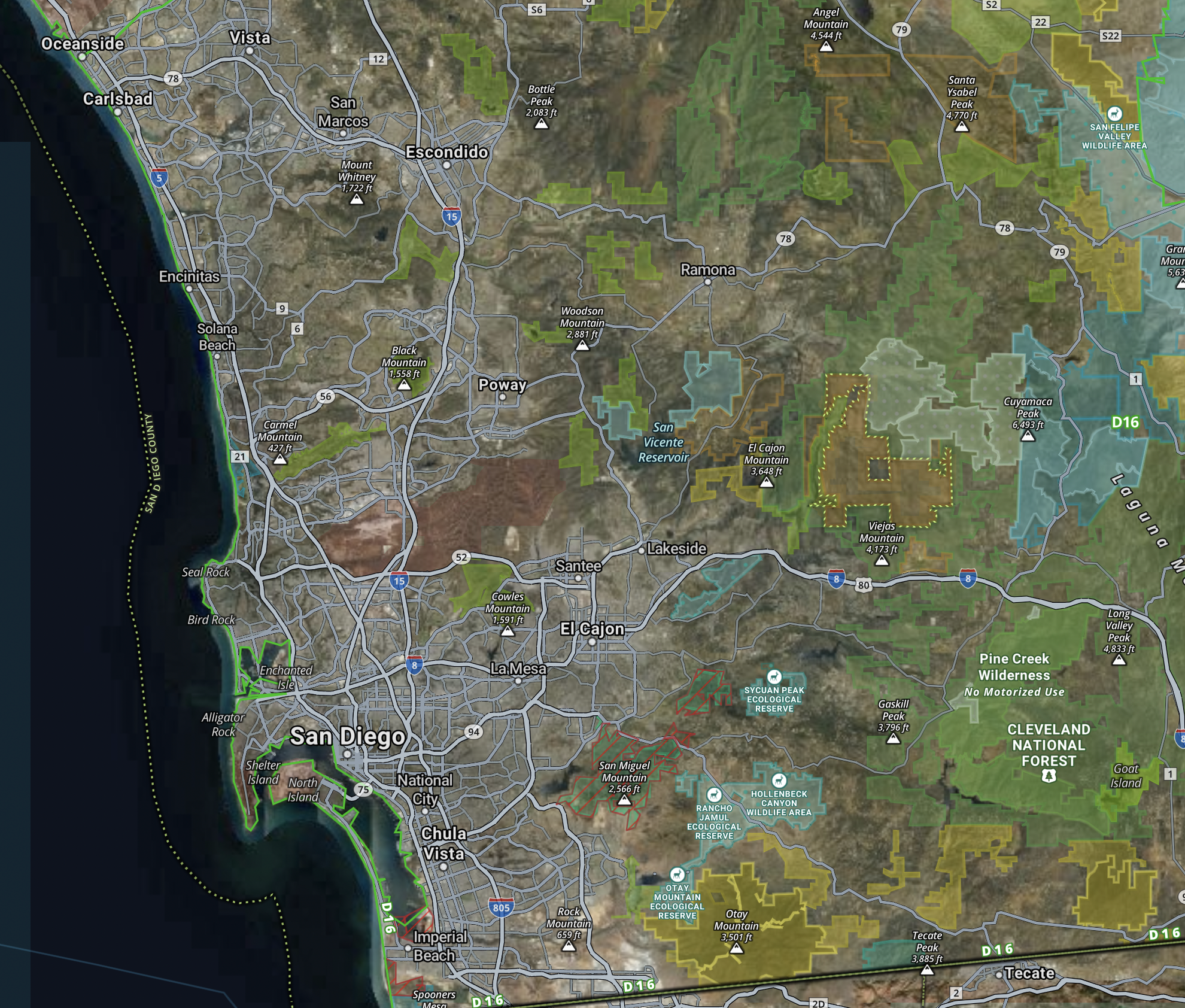
onX image of San Diego region showing access layers
Most planning pieces about a new piece of country start with where the birds are. This one cannot, and that is the single most useful thing I can tell you about San Diego County quail.
The reason is that the inland half of the county holds California quail (Callipepla californica) in perfectly good numbers on hundreds of thousands of acres of public land, and a hunter can still drive four hours, park at a trailhead, and discover that the drainage he came for has been closed since June. Cleveland National Forest stacks four kinds of legal restriction on top of one another. Finding cover is the easy half. Proving you are allowed to stand in it is the half that eats the trip.
That matters more to me now than it would have five years ago, because the next time I go south, Alan comes with me. He is a three-year-old English cocker, he works close and hard, and he does not care that a spot is legal — he cares that there is water in it within a couple of hours of the last water. A closure that pushes me two drainages over is an inconvenience for me and a real problem for him, because the fallback drainage is the one I have not scouted a water source in. So the closure map and the water plan are the same document, and both get built before I load the truck.
I lived in SoCal for a stretch and spent a good number of days on the Cleveland and the East County BLM — day-trip scouting, plus one early-season half-day in the Cuyamaca foothills, none of it behind a dog. What follows is what I have assembled since, and where it runs out.
Four Things Can Shut a San Diego County Drainage
They stack, they are administered by different agencies, and none of them appears on the others' maps.
Forest orders. Wildfire-driven closures, some emergency and some standing, issued by the Cleveland and updated without much fanfare. A spot open last October is not necessarily open this one.
Private inholdings. The Cleveland is not a solid block. It is shot through with private parcels, and the boundaries do not follow terrain in any way you can read off a ridgeline.
Watershed restrictions. Reservoir watershed lands carry their own access rules, set by the water agencies that own them rather than by the Forest Service.
Species closures. Habitat protections for listed riparian species close creek corridors and the roads into them. The temporary forest order that took effect April 30, 2026, for instance, closes Orosco Road, Boden Canyon Road, and Santa Ysabel Road to protect arroyo toads. The riparian closures are the frustrating ones, because riparian bottoms are exactly where quail want to be in October.
Building One Legal Map Out of Four Sources
No single source shows all four layers. The hunters I talked to at the Otay Lakes club both build the map themselves, from the Cleveland NF alerts and forest orders, CDFW's restricted-area maps, and a land-ownership layer in OnX. Both check the forest orders again within a week of leaving, and both were emphatic that a map built in July is a fiction by October.
Both also carry paper. There is no cell service across most of that back country, and a closure map living only on a phone at 12% battery is not a closure map. I will be printing mine — it is the least glamorous item on the list and the only one that gets checked at a truck door.
What Is Left When You Subtract the Closures
More than you would expect, and it concentrates in three places.
The Descanso Ranger District. The eastern foothills from El Cajon Mountain through the Cuyamaca Rancho country up to Mount Laguna. Chamise, manzanita, and scrub oak at the lower elevations; oak woodland and conifer up in the Laguna belt. This is the core of the county's quail ground. The two hunters I spoke with both start low here, in the chaparral around El Cajon Mountain and the western Laguna foothills, and that is where I intend to point a first morning.
The Palomar Ranger District. The northern district — Palomar Mountain, the upper San Luis Rey watershed, the country around Pala. Similar chaparral, more elevation relief, and harder access.
McCain Valley and the East County BLM. BLM administers the transition ground between coastal chaparral and Sonoran desert on the Anza-Borrego edge, and the McCain Valley Resource Conservation Area is the productive piece, reached from the Boulevard exit off Interstate 8 by Old Highway 80 and McCain Valley Road. California quail hand off to Gambel's quail (Callipepla gambelii) as you move east.
The Trabuco district, over in Orange and Riverside counties, is Cleveland ground but not San Diego ground and not much of a quail proposition. I mention it only so you know why it keeps appearing in searches.
Fire Writes the Cover and the Access Both
Cedar in 2003, Witch and Harris and Poomacha in 2007, Lilac in 2017, Valley in 2020, and dozens more. By most estimates, chaparral takes five to fifteen years post-burn to reach peak quail cover and twenty-five to thirty to mature. That arithmetic cuts two ways here.
Where reburn intervals have been short, the cover is stuck young and thin, and the bird numbers reflect it. Where a footprint has been left alone into that window, it is the best cover in the county. The 2020 Valley Fire, 16,390 acres of Cleveland ground southeast of Alpine, is six years out this fall.
The tool for this is CAL FIRE's fire perimeter data laid over the land-ownership layer, which is also how the fire history and the closure history end up being the same off-season research project. San Diego County's chaparral is among the most fire-stressed ecosystems in the state and increasingly fragmented by development, and the connectivity work CDFW's South Coast Region and groups like the Endangered Habitats League are doing on habitat linkages is what determines whether there is huntable quail country here in thirty years.
Two regulations frame the rest. San Diego County sits in quail Zone Q3, where the 2026-27 season opens Saturday, Oct. 17, and runs through Jan. 31, with a daily bag of 10 and 30 in possession. And nonlead shot has been required for any take with a firearm anywhere in California since July 1, 2019.
The Elevation Belts, Compressed
Roughly 1,500 to 2,500 feet is the lower chaparral, and the densest quail ground: chamise, manzanita, scrub oak, birds in burn regrowth and along seasonal creek bottoms, most of it reachable from Sunrise Highway east of Descanso. From 2,500 to 4,500 the country turns to oak woodland — coast live oak, black oak, mixed chaparral, California quail still present, mountain quail beginning at the top end, and noticeably more weekend pressure out of San Diego. Above 4,500 in the upper Laguna belt, mountain quail (Oreortyx pictus) become the more reliable bird and California quail thin out.
That compression is a gift to a two-day trip and a trap for a dog. Three cover types in a thousand vertical feet means the water situation changes faster than the map suggests, and October highs in the foothills still run to 90 under a SoCal high. My plan is the first ninety minutes of light and the last ninety, with Alan's water carried rather than found — five liters for me, a separate budget for him, and a midday that is not negotiable. Snake gaiters go in the truck through October; Pacific Coast tick is endemic, so permethrin on the clothes and a full check at the end of the day; brush pants, because the chamise is the same chamise as Mendocino and it does the same thing to cheap fabric.
The Part No Agency Website Contains
Here is the honest limit of this file: I can tell you which layers to check and which districts survive them, and I cannot tell you which canyon holds birds on a Tuesday in October. Nothing in the forest orders, the BLM status maps, or the fire perimeters gets you to a covey. That is local knowledge, and in this county it is held by a small number of people who mostly do not publish.
So here is the ask. If you hunt San Diego County quail seriously — particularly the burn footprints around El Cajon Mountain, or the McCain Valley ground — I would like to hear where this piece is wrong before I go, not after. hello@californiaupland.com. I will name you in the correction if you want it, and not if you do not.
Related reading:
External: USFS Cleveland National Forest · BLM El Centro Field Office · CDFW Upland Game Bird Hunting
Get the weekly digest. One email each Sunday with the week's pieces, plus the California Upland Season Dates & Limits Cheatsheet PDF as a free download for new subscribers. Subscribe →
Peter Burnham grew up in Nevada hunting chukar in the Sierras and dove in the valleys and hunts behind Alan (a three-year-old English cocker). Read more → · Subscribe to the weekly digest →
